


Golden Software has continued to enhance the 3D drillhole viewing functionality in the latest release of its Surfer mapping and 3D visualization software package…
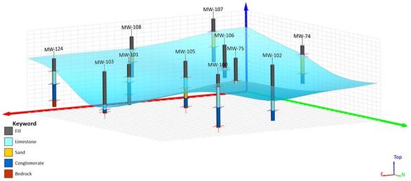
Golden Software has continued to enhance the 3D drillhole viewing functionality in the latest release of its Surfer mapping and 3D visualization software package. Overall, the new version of Surfer provides users with several upgrades to save time and streamline creation of subsurface maps.
Surfer is used by more than 100,000 people worldwide, many involved in environmental consulting, water resources, engineering, mining, oil & gas exploration, and geospatial projects. Surfer enables users to model data sets, apply an array of advanced analytics tools, and visually communicate the results in a way that even the non-technical stakeholders can understand.
Divided into two categories, 3D View and Enhanced Usability, the following upgrades have been made in the latest release of Surfer available today:
3D Viewing
- Create, Edit,
Content Original Link:
" target="_blank">


